Handpicked: The Best Experiences on Lewis & Harris
Where to: watch seals bask, warm up in a beachside sauna, sip the island’s finest coffee, spot soaring eagles, find peace at a medieval church, and savour Harris Gin by the fire.
Visiting Lewis and Harris is a journey I delayed far too long.
Scotland’s Outer Hebrides always felt a step further than the Inner Isles: a journey that demanded extra time, more intention, and more of my tightly-guarded holiday allowance — which was always reserved for foreign climes.
But after hearing enough rapturous tales of Caribbean-like beaches I finally gave in. And yes — the stories are true.
Now that my jaw has returned to its rightful place, I want to share my favourite moments from Lewis and Harris — one island with 2 distinct personalities: sometimes raw; sometimes refined; always restorative.


The CalANAIS STANDING Stones - Lewis
At Callanish, on the west coast of Lewis, there lies 50 Standing Stones arranged in a distinctive cross-like formation a large cruciform shaped stone circle, their Lewisian gneiss surfaces worn smooth by 5000 years of Hebridean weather.
The Calanais Stone circle is one of the most remarkable and atmospheric Neolithic stone circles in Britain, with its dramatic setting overlooking the surrounding lochs adding to its mystique.
This impressive stone circle sees far fewer visitor numbers than Stonehenge, although it does feature on coach tour itineraries.
If you arrive early enough, chances are that you can have this impressive stone circle to yourself. I visited at 8am there was nobody else around.
Stay late and you can stand under the same constellations as our Neolithic ancestors and ponder the monument's elusive purpose.
The Calanais Stones are free to visit all year around.
HOW TO GET TO THE CALANAIS STONES
12m west of Stornoway off the A859, Isle of Lewis.
There is a small surfaced car park next to the standing stones.
During the visitor centre redevelopment (anticipated reopening in 2026) there will be no access or parking for coaches. Drivers are advised to park on the shore road (if there is space) and follow the signs to walk up the hill to the stones. Please follow this page for updates.
There are bus services from Stornoway to Callanish.
58°11'51.2"N 6°44'42.5"W (opens Google Maps)


WAtch SEals BaskING – HARRIS
On the east coast of Harris there is a narrow single–track road called The Bays that connects Rodel to Tarbert. Along this road is a seal viewing point with an in-situ telescope. I happened upon this my chance, and it provides a view of a rock that is regularly used by Seals to bask on.
This is one of the closest viewing points to watch seals in Scotland. I found the experience wonderful, as the seals seemed unbothered by any human presence. I would recommend going in early morning or evening for the best chance of seeing seals here.
The Bays Road weaves its way through between the bays and settlements of the low lying and rocky landscape of south-east Harris. This road connects to the Golden road (see below) and makes for a wonderful tour of the overlooked east coast of Harris.
HOW TO GET TO THE SEAL VIEWING POINT
Take the A859 to Rodel, turn left just after St Clements Church along the single-track road. The viewing point is located a few miles along this road.
The Bays is a narrow single-track road but has numerous passing places, and is suitable for cars or vans.
57°46'54.4"N 6°54'46.5"W (opens Google Maps)

The Golden Road

DRIVE THE GOLDEN ROAD & THE BAYS ROAD – HARRIS
The east coast of Harris is often overlooked by travellers for the beaches of the west coast.
This is great news for anyone wanting to savour the sinuous miles of single-track tarmac that run from St Clements Church at Rodel with Tarbert. Driving in this northerly direction enables you to have the sun (if it appears) behind you as you thread your way through the lunar-like landscape that inspired scenes from Stanley Kubrick’s 2001 A Space Odyssey.
The southern part of this route is called the Bays Road and weaves its way through between the bays and settlements of the low lying and rocky landscape of south-east Harris. This road connects to the Golden Road (named due to the very high cost of building it through this difficult terrain) which leads into Tarbert.
HOW TO DRIVE THE ROUTE
Take the A859 to Rodel, turn left just after St Clements Church along the single-track road. Just after Aird Mhige, turn right and take the Golden Road to Tarbert.
The Bays Road and the Golden road are narrow single-track roads with numerous passing places, and aesuitable for cars or vans.
The complete route is a wonderful experience and takes around 2 hours.
57°44'26.9"N 6°57'39.9"W (opens Google Maps)


Horgabost Beach’s Seasonal Sauna Experience - HARRIS
Horgabost is a beautiful beach on the west coast of Harris with white sands, turquoise waters, and, during September–November: a mobile sauna.
During the Autumn, Horgabost beach hosts the Saltbox Sauna: a mobile wood-burning barrel sauna that provides an elemental wellness experience. The Sauna seats 4-6 people and can be booked privately by the hour or single seats (£20) can be purchased in mixed public sessions. There are also offer wellness packages with face scrubs and balms.
I found the combination of hot sauna and a cooling dip in the sea to be a rejuvenating and fun way to immerse myself in the elements of the Outer Hebrides.
If you stay at Horgabost beach campsite (which I did) you could think of this as a fabulous wellness experience for very little money.
horgabostcampsite.couk
Do check when the Saltbox Sauna will be at Horgabost beach at the time of your trip. Saltbox also have other mobile Saunas on beaches around the Outer Hebrides.
HOW TO GET TO HORGABOST Beach
Follow the A859 road on Harris: the beach is located just 0.5 miles west of the road near the Horgabost campsite and layby.
57°51'48.1"N 6°58'49.8"W (opens Google Maps)


STAY AT The Gearrannan Blackhouse Village – LEWIS
Wake to the sound of Atlantic waves and spend evenings beside a fire in your own historic dwelling.
Nestled on a hillside overlooking the Atlantic, this restored village is run by the Garenin Trust and offers self-catering accommodation ranging from a 2 person dwelling to deluxe family cottages.
Each cottage retains its own character and bears the name of the family who once called it home. These remarkable buildings were once home to Highlanders who lived with their animals in single-room homes with packed earth floors, drystone walls, and thatched roofs. The constant peat fires gave the blackhouses their name, from the soot-blackened interiors.
The village remained inhabited until 1974, with women traveling to Stornoway for fish processing work while men journeyed as far as South Georgia for the whaling seasons.
Today, the settlement combines self-catering accommodation with a living museum. You can go for the day and watch Harris Tweed® weaving demonstrations, visit the cafe, and hear Gaelic conversations accompanied by the rhythmic clatter of looms. The gentle Hebridean staff bring warmth to this atmospheric setting.
While there, be sure to venture beyond the village. Its perch along the Isle of Lewis’ western coast offers prime access to spectacular coastal hikes.
Visting information at gearrannan.com
Book accommodation at gearrannan.com
How to get to Gearrannan
Gearrannan is about 25 miles (40km) to the west of Stornoway, and about 45 miles (56km) north west of Tarbert. Follow signs for Càrlabhagh (Carloway) on the A858.
Opening hours are Monday to Saturday 9.30 to 5.30
58°17'47.4"N 6°47'34.9"W (opens Google Maps)

EAGLE SPOTTING – HARRIS
While I’ve never fancied myself as a birdwatcher, something about The North Harris Eagle Observatory appealed. The Observatory is situated right in the heart of the territory of a pair of golden eagles, an iconic species that I have never seen outside of a David Attenborough TV programme.
The Observatory is large timber hide, reached by a scenic two mile walk from the car park.When I arrived there were 4 ‘birders’ looking intently through binoculars onto Glen Meavaig.
We watched. We waited. But the Eagles refused to perform for us.
Although I did not hang around long enough to see a Golden Eagle, it was great to hear tales of eagles, otters, and whales from people who based their holidays around wildlife spotting.
We joked that I would see an Eagle on the walk back, but my luck was out that day. I did find the experience meditative though – to gazing into the landscape with such concentration.
Bring a pair of Binoculars. Entry is free.
HOW TO GET TO THE North Harris Eagle Observatory
Drive to the observatory car park (free parking) on the B887 at Gleann Mhiabhaig. Walk to the observatory via a 30 minute walk down the track from a car park.
57°53'51.8"N 6°48'15.2"W (opens Google Maps)

St Clements CHURCH, Rodel – harris
Experience the quiet tranquility of an isolated medieval church, overlooking the sea.
St Clements Church is the largest medieval church in the Outer Hebrides. Of all the churches in the islands, only Iona is larger. The church is located at the southern end of Harris and named after the patron saint of sailors.
The interior of the church is dark and bare with a neatly laid floor of square flagstones that have been polished smooth by the passage of many feet. The lack pews and stained glass windows giving the church a unique atmosphere of ancient silence.
This 16th-century church is rare in Scotland as it is one of the few examples of a Roman Catholic chapel that escaped defacement during the Protestant Reformation of the 16th century. The church is strongly linked to Clan MacLeod of Harris and several clan chiefs are buried here.
HOW TO GET TO St Clements CHURCH,
Take the A589 to Rodel on the south coast of Harris.
Open dawn to dusk all year.
57°44'26.9"N 6°57'39.9"W (opens Google Maps)

SIP HARRIS GIN BY THE FIRE AT THE ISLE OF Harris Distillery
No visit to Harris is complete without sipping Harris Gin by the open fire at Harris Distillery. It’s a sophisticated place to hang out with comfy chairs and a warm welcome.
Established in 2015 on the shores of East Loch Tarbert, the distillery began with their award-winning gin, distilled with locally harvested sugar kelp seaweed, before releasing The Hearach single malt Whisky in 2023, marking the first legal whisky ever produced on Harris.
The Isle of Harris Distillery is run by around forty-five local employees and embodies what they proudly call their "Social Distillery" mission. The Distillery aims to help reverse the decades-long population decline that has threatened local traditions and forced young Islanders to seek work elsewhere.
OPENING TIMES
The distillery is open to the public Monday to Saturday from 10am to 5pm.
There are free sample to taste and guided tours that run at various times from March to October at £12 per adult
In the summer there is a canteen, although I missed out on this experience as I went in September.
HOW TO GET TO HARRIS DISTiLLERY
The Distillery is located near the ferry terminal at Tarbert, the main town on Harris.
57°53'51.8"N 6°48'15.2"W (opens Google Maps)

Luskentyre Beach – harris
Luskentyre Beach is perhaps the most famous beach on Lewis and Harris, known for its turquoise water, white sand dunes, and stunning mountain backdrop.
With its numerous awards and features in magazines such as Conde Nast Traveller, I thought it might be over–crowded.
However, I’m pleased to report that the beach does indeed live up to the hype, and when I visited in late afternoon in September, it was almost empty. I ran along the huge sweep of white sand and turquoise sea and felt like I was in a perfume commercial.
My only caveat is that I preferred Horgavost Beach because there is campsite nearby, which means there are facilities and you don’t have to drive to get there. Although, to be fair, you could try to secure an official camping spot for your camper-van or mobile home along the beach road.
HOW TO GET TO Luskentyre Beach
Drive from Tarbert towards Scarista and take a right turn off the A859 at Seilebost. The 3 mile single-track road out to the beach is called Luskentyre Road.
57°53'11.8"N 6°57'34.8"W (opens Google Maps)

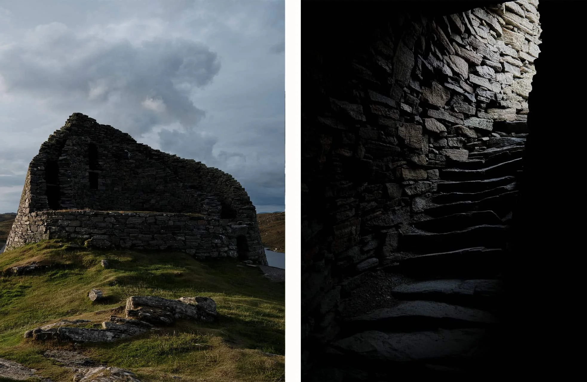
Dun Carloway – Lewis
A well-preserved ancient Broch (tower) that sits atop a rocky hill on the Isle of Lewis with views over Loch Roag. Dun Carloway was built around 200 BC as a residence, a defensive structure and symbol of power. It is one of the oldest existing fortifications in Britain.
At Dun Carloway Broch you can wander up the still intact, internal staircase to the floor where people would lived above the ground floor that housed their farm animals.
Local Legend tells of Dun Carloway being used as a hideout by cattle thieves The Morrisons of Ness. When MacAuley, the aggrieved owner of the cattle, found out, he used two daggers to climb the outer wall and smoked out the thieves with burning heather.
Dun Carloway is a better preserved than most ruins of this age and is worth a visit if you’re visiting the west coast of Lewis.
OPENING TIMES
Dun Carloway is free to visit and access 24 hours a day.
HOW TO GET TO Dun Carloway
1.5m South of Carloway, about 16m North West of Stornoway, Lewis on the A858.
Free Parking available.
Access to the site is via a short rough path.
The visitor centre is open from 1 April - 30 Sept
58°16'10.4"N 6°47'38.2"W (opens Google Maps)


