Handpicked: Atmospheric Walks on Scotland’s Islands
Five Islands, Five Worlds — Mull, Arran, Skye, Raasay, Ulva
Stepping onto a Scottish island that you can only reach by crossing water feels special. You arrive primed by the sea air, ready for the next adventure.
On these atmospheric walks on Mull, Arran, Skye, Raasay, and Ulva, you might find yourself on a coastal path as a White-tailed Eagle glides by, pausing at the ruins of a clearance village, or gazing at seals basking by turquoise seas. Perhaps you'll indulge in forest bathing near a whisky distillery, climb a scree slope on a Cuillin mountain, or find yourself stood shrouded in low cloud on the summit of an extinct volcano.
Some gentle, some fierce. All will make you feel alive.

Isle of Skye: The Quiraing Walk
57°37'41.4"N 6°17'28.0"W (opens Google Maps)
The striking cliffs of the Quirang were formed by an ancient landslip. Legends of fairies and dragons abound here, and I can understand why: there is an air of mystery to the place.
This route is said to be the Isle of Skye’s most picturesque walk.
I can’t offer an opinion on this, as when I did the walk with a friend, the cloud was so low that we saw very little. This made the walk otherworldly, as we walked past rock formations shrouded in cloud, heard disembodied voices echo around us, and saw ravens glide close by.
I would love to return, but perhaps I should just hold onto this special memory in the mountains of Skye.
How to get to the START OF THE WALK
The Quiraing is a challenging 7km walk that begins at the pay-and-display car park situated on a minor road connecting Uig and Staffin. The approach road is narrow and very steep.
See the route on walkhighlands.co.uk

Isle of Raasay: Circular Walk
57°21'01.8"N 6°04'54.5"W (opens Google Maps)
A meandering exploration of the area around Inverarish village on Raasay, this walk includes a secluded beach, beautiful coastline and wonderful views. My favourite section is the path through woodland that has scores of wild mushrooms and a fairytale atmosphere.
I can recommend a visit to Raasay Distillery, which has an excellent cafe.
How to GET TO The START OF THE WALK
The walk is 7 km long and begins at the ferry jetty on Raasay.
See the route on alltrails.com
How to GET TO The Isle of Raasay
Take the (15 minutes) CalMac ferry crossing from Sconser on Skye.
WORTH KNOWING
For dining, Raasay House and Raasay Distillery offer excellent options.
Overnight stays can be arranged at the Rasay distillery.

Isle of Ulva: Walk to Ormaig
56°28'50.7"N 6°09'12.1"W (opens Google Maps)
Ulva to Ormaig is an out-and-back walk that explores the beautiful southern coast of Ulva. It's tranquil and a great place to spot White-tailed Sea Eagles.
Take the short ferry crossing from Mull to Ulva, walk along quiet lanes into the old-growth woodland, pass by the herd of Highland Cattle, climb up over the hill. The remote east side of Ulva now stretches as far as your eyes can see. Your only company at this point will be the Eagles above and Deer watching from the hills.
Continue down the path for 2-3 miles through the ruins of the clearance villages of Ormaig and Kilvekewen. If you look towards Cragaig Bothy (privately rentable) and you might catch seals basking on one of the small islands in the bay. Walk until there is no more path. Make tea, gaze at the ocean, and feel the silence.
Make the return journey to the Jetty for a plate of Langoustines at the Boathouse Cafe.
How to get to THE START OF THe WALK
The walk is 13 km (8 miles) and begins from the jetty on Ulva.
See the route on walkhighlands.co.uk
How to get to THE ISLE OF Ulva
Ulva is a three-minute ferry crossing from Mull, operating on demand from 9.00am to 5.00pm, April 1st through October 31st.
Note that there are no sailings on Saturdays, and Sunday service runs only from June to August.
The Isle of Mull: Ben More Walk
56°23'55.1"N 4°34'15.0"W (opens Google Maps)
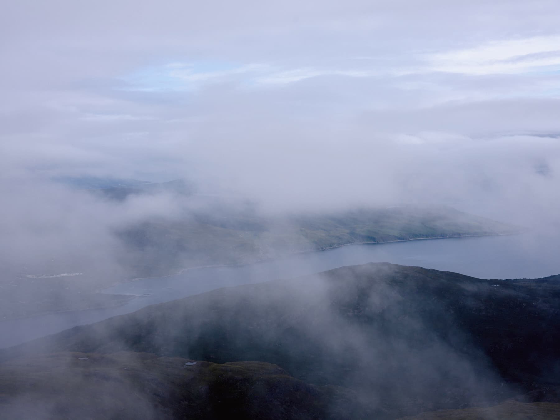
Ben More, a 60–million–year–old extinct volcano, is the highest mountain in the Scottish Isles. At 966m, Ben More’s imposing triangular shape dominates the landscape of Mull, but it is accessible and makes for a spectacular hill walk.
On clear days, the panoramic views over the Isle of Mull and surrounding islands are said to be astonishing. Although as you can see from the photo above, I saw only a glimmer of this. However, the experience of being on this high mountain enclosed in shifting clouds was wonderful.
How to get to THE START OF THe WALK
The main car park for Ben More on Mull is situated near Dhiseig, at the head of Loch na Keal. A spacious grassy area lies just east of a bridge on the shore side of the A849, marking the starting point for the mountain’s marked path.
The route is approximately 6 miles along a rocky, steep, and rugged track, recommended only for experienced hill walkers.
See the route on walkhighlands.co.uk
For those seeking guidance, Mull Magic offers guided walks.
How to get to THE ISLE OF mull
Take the car and passenger ferry from Oban to Craignure on Mull.
Book your crossing at CalMac Ferries

Skye: Blà Bheinn Walk/Scramble
57°13'10.9"N 6°02'33.6"W (opens Google Maps)
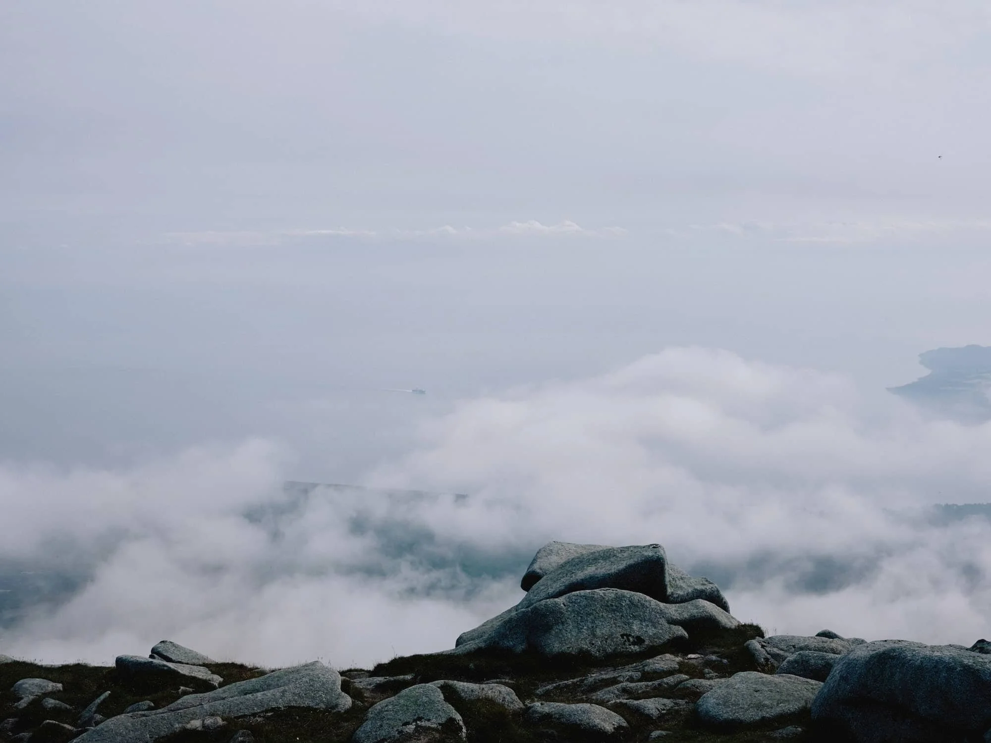
Blà Bheinn (Blaven) is the only stand-alone Cuillin on Skye and one of the most magnificent mountains I’ve climbed.
When I climbed this isolated citadel, it was shrouded in low cloud, and I imagined I was entering the mountains of Mordor from The Lord of the Rings.
Blà Bheinn may look imposing, but it's one of the easiest Munros on Skye to ascend. The route is rocky though, and some scrambling up a scree slope is needed.
Apparently, the summit panorama of the entire Cuillin Ridge is incredible..
I may have to climb it again.
How to get to THE START OF THe WALK
The car park for Blà Bheinn is located off the B8083 road near Loch Slapin. It's a small parking area signposted from the main road.
See the route on walkhighlands.co.uk
While Blà Bheinn is often regarded as one of the more accessible Skye Munros, it should not be underestimated. The summit area is rocky and exposed, and in mist, navigation can be confusing. The ascent up Blà Bheinn should only to be attempted by experienced hill walkers as there is with plenty of scree, and finding the right route up can be difficult.
Arran: Goatfell Walk
55°35'29.3"N 5°09'23.0"W (opens Google Maps)
Goatfell is the first thing that you see when you disembark from the ferry. The mountain dominates the landscape of Arran and has been a magnet for walkers for decades.
At 874m, Goatfell is technically a ‘Corbett’, not a ‘Munro’ but it certainly feels like climbing one. The route is of moderate difficulty along well trodden paths.
When I climbed Goatfell with my daughter, the Midges were so bad that we almost turned around. However when we reached the top everything melts away into the stupendous views over the island.
How to get to THE START OF THe WALK
The route is an 11km out-and-back and starts from Brodick Castle.
See the route on walkhighlands.co.uk
How to get to Arran
Take a ferry from Troon to Brodick (80 mins), Ardrossan to Brodick (55 mins) or Claonaig on Kintyre to Lochranza (30 mins).
Notes on Walking in Scotland
In the words of the great Scottish comedian Billy Connolly to visitors to Scotland, “If you don’t like the weather, just wait five minutes!”. The summits of mountains in Scotland are often covered in low cloud, which can make navigation confusing and give rise to wet, cold conditions.
So carry a full set of waterproofs, warm clothes, GPS (I use the Gaia app on my phone), map and compass, spare food and water, even in the summer.
RELATED POSTS


RELATED POSTS